What about walls?
Keeping people out, keeping people in, and more....

So we have SUN!!! It has been sunny in Madrid now for two weeks, after almost six weeks of rain, and bumping the storm-system name-game up to Pedro; it was at Oriana at last newsletter, the last two systems coming from the northwest instead of southwest like previous storms.
Madrid weather has been positively spring-like, which brings to mind the weather saying “en febrero el perro busca la sombra” (in February the dogs look for the shade), because the sun is starting to get almost too hot for basking – incidentally that saying is good for practicing your r’s and rr’s.
And true confession: the other day I was wearing tights, and they were driving me crazy (what was I even thinking??? I hate tights!) so took them off and went bare-legged. Not at all chilly, yay! Even though I of course know that winter is not over, and the storm name-game will continue. Frankly, I want to see what they will do if they run out of names, which seems likely with eight months left in weather year (remember, that is October 1 to September 30 of following year) and we only have five more names: after Pedro we could have Regina, Samuel, Therese, Vitor and Wilma.
We are also in Lent, if you are giving something up to prepare for Easter, wishing you courage and willpower: someone I know often does a dry Lent instead of dry January. But even as you fullfill your Lent promises, do not forget “torrijas”, typical Spanish sweet for this time of year that will soon be in all pastry shops and many bar-cafés. It is sort of like what we call French toast in the USA: bread slices soaked in milk then fried in butter, here often with some lemon and cinnamon AND an important variation: dipped in wine instead of milk. Yes, really and truly true, and really and truly yummy. Especially good with dark vermouth, as in typical bar near Puerta de Sol here in Mad City.
Change of subject…… to walls.
Hard to believe it has been more than 35 years since the Berlin Wall came down (November 9, 1989). Thirty-five years is a longish time, but that history-changing event is relatively forgotten nowadays, so much has happened since then. (as an example: a friend of my Prague-lived sister did a tour in Prague recently and the guide was very good on old history, but barely touched the Velvet Revolution that followed the fall of the wall).
That wall and the political wall between western and eastern Europe have been on my mind recently, having just finished a very good book about the Cold War (in Spanish, title La Guerra Fria, una Historia Inacabada, authors Carlos Sanz Diaz and Jose Manuel Sáenz Rotko). Very interesting read, and with a lot of implications for current history. If you like history, if not this book highly recommend you find something good about the Cold War period (say… 1947 – 1991), read and ponder.
I’m looking for a “sequel” to understand how Eastern Europe rebuilt their democracies, which has some parallels to Spain rebuilding after Franco’s dictatorship. Any suggestions? Just getting ready to read Timothy Garton Ash (British journalist-historian) book The Magic Lantern, which is probably as much he-was-there journalism as history but seems a good starting point.
That is sort of a strange way to back into a post about….. walls. Medieval city walls, to be precise. Or not so strange, because the Berlin Wall was a city wall with large implications that had several of the functions that medieval city walls had, functions which are not / were not on most people’s radar as functions for a city wall.
Usually we think of city walls as a way of keeping out the city’s enemies. Tall and thick, city gates with scary-big doors or grates, guards patrolling the ramparts and at the gates, maybe even an attached castle. Sound right? Yes, that’s one function of city walls, but there are others, as seen in Berlin and in medieval times.
Walls also could keep people inside, like in Berlin, or in medieval times, gates could close to keep a possible criminal inside for arrest (thief, tax evasion, murderer, other?). Or set very clear boundries between different territories, in Berlin, two economic systems, and in medieval times clearly show the division between “civilized” urban, and surrounding countryside that existed to supply the city. Or flip that, the city was market for countryside products, and supplier of products the countryside didn’t have.
Theoretically the walled city or town was there to protect country people in case of danger or attack (a very real danger for a long period in medieval Iberia, not-yet-Spain), though that probably didn’t always work. And the other important function of city walls was…. taxes. As in, what products entered the city for sale paid tax at the city gate, what was sold outside the city walls paid no tax or less tax. So of course the farmer with a cart of potatoes would set up his stall just outside the walls – this sounds like fake news, but the Madrid’s Plaza Mayor started as a market square just outside the east gate of the 12th century walls.
Can you tell how much I like medieval city walls? Almost as much as bridges, which might be subject for a future post. And here’s a thought: what is the modern equivalent of city walls, fulfilling at least some of the same functions? The ring road (or beltway), because it delimits urban and “rural” or nowadays urban and ‘burbs, also likely has some tax implications; think of the Gordian knot entrance points as city wall gates and you have a roughish comparison to long-ago walls.
In Spain city walls started to lose their functions in the 18th century, but history still had some surprises for Spain: the early 19th century saw the Peninsular War against Napoleon’s occupation, then a complicated period with bad or ineffective monarchs and social unrest when walls were not a bad thing to have around a city. Things started to calm down in the middle of the century, and with less unrest and growing urban population, the medieval walls constricted city growth so many cities started to demolish all or at least part of their medieval walls.
So what were the city walls like?
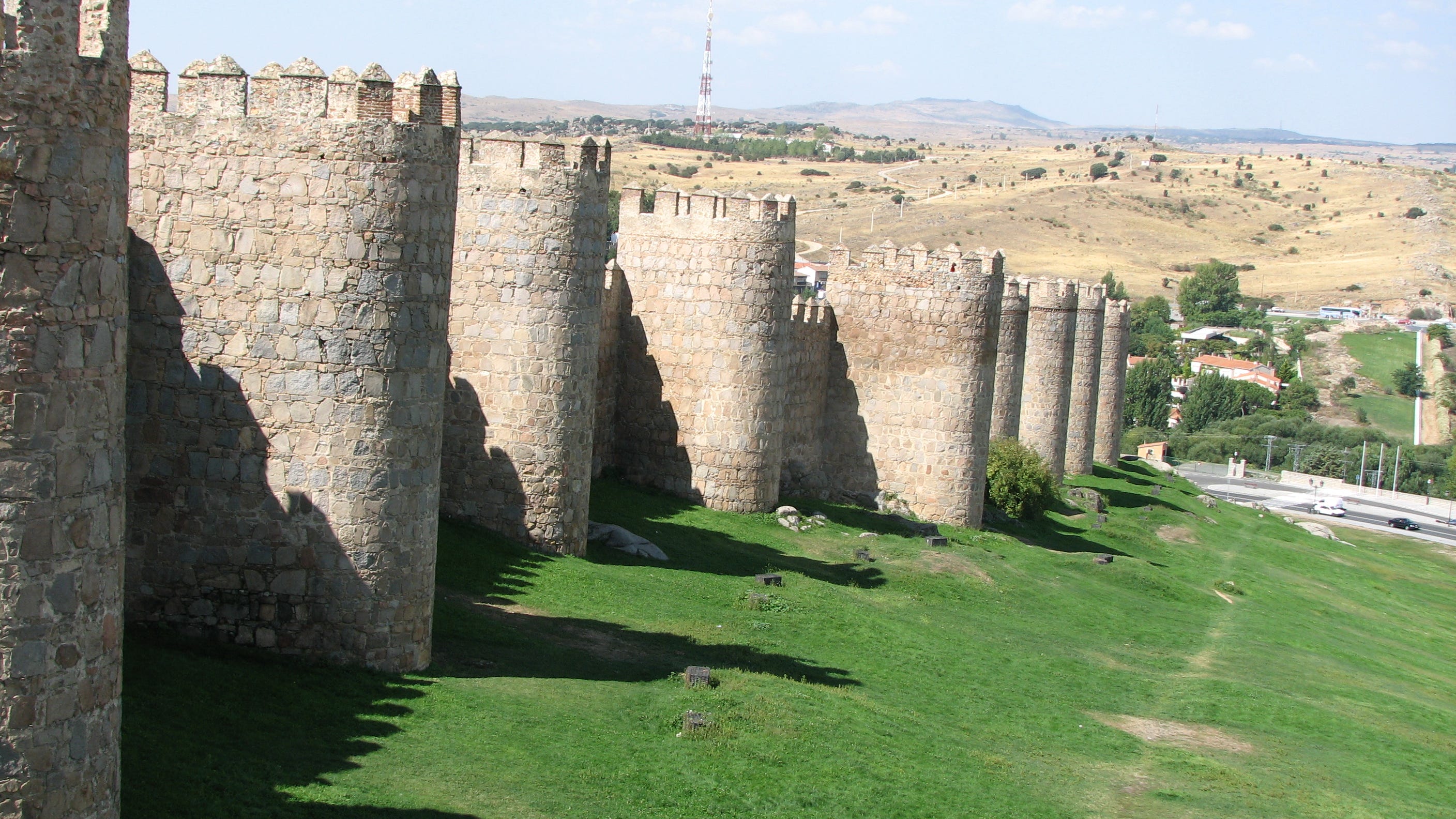
The walls were usually ten to fifteen meters high (33-50 feet) and three to five meters wide (10-16 feet). The structure was outer and inner walls of solid stone, with rubble or filler in between the two walls. What we see as towers were usually solid, more butresses than living quarters, except maybe by the city gates for the guards. The most important or most vulnerable city gates sometimes had a double-dogleg entrance: enter outer gate, right angle turn in one direction between high walls then a second right angle turn in the opposite direction. That sounds complicated but if you think about it or draw it, you can see how a low-tech construction technique made it very hard for an invading army to charge the gate effectively (good example: Puerta de Alcántara in Toledo).
What are the most interesting city walls to see nowadays in Spain?
Ávila has a full perimeter of 12th century walls, built on remains of earlier walls. The entire distance is about 2.5kilometers, people can walk on about 1.7 kilometers. Fee charged. (photo is from Ávila)
Lugo has a full perimeter of 3-4th century AD Roman walls. More than 2 kilometers perimeter and wide enough on top (almost) for a small car, Lugo’s walls are the city’s jogging and power-walking track. No fee – and this is a should-do for anyone travelling by car between Madrid and Galicia.
Bits and pieces of old city walls in Toledo, Zamora, Salamanca, Barcelona, Badajoz, among other cities. And once you are a wall-sleuth, you can usually identify where the walls were on a city map: hints are a long curved street with few perpendicular cross streets and street names like “ronda” or “cerca”. Seeing where the walls still exist and guessing were they used to be and were torn down to allow the city to expand also tells you about the city history and urban development.
Villages had walls too. If a small town had or still has a wall, take note. It might be in a very strategic location (protecting a river ford, on a hill overseeing a huge territory, protecting a road), or perhaps it was a market town or administrative center. Lots of villages have remains of their walls – Ayllón and Pedraza in Segovia, Madrigal de las Altas Torres in Ávila, Buitrago de Lozoya in Madrid. Two small but charming villages, totally off usual tourist routes have full perimeters of walls: Rello in Soria and Urueña in Valladolid.
And Madrid?
As history buffs know, Madrid is a newish city by European standards. It was founded as a Muslim military fortress with attached village in the middle of the 9th century, so the first walls were from that period (see end for summary of Madrid’s walls). During the so-called Reconquest* Madrid was “conquered” by the Christians in 1083-1085. Madrid lore says that king Alfonso VI of Leon (a Christian kingdom in north-ish Iberia) was camped at the gates of the city waiting for the right moment to attack; one night the stars in the Big Dipper (in Spain called the Great Bear) were especially bright which he took as a sign that an attack would be successful, so he ordered an agile and clever local man to climb the Muslim walls and open the gates from the inside, thus taking the city without a huge battle and giving Madrid citizens the nickname “cats” (gatos) because of the climbing agility of the local man who facilitated taking the city.
That’s a great identity legend but the truth is much more mundane: a deal was done between Alfonso VI and the ruler of Toledo city-state, consolidating Christian control of the north central plains, Madrid, and moving the border between Christian and Muslim Spain south to the Tajo river, more or less. After taking the town, the Christians enlarged the walls to encircle mostly Christian population existing outside the first line of walls.
Lots of history happened, and a maybe enlargement of Madrid’s walls in the middle of the 15th century, no longer for defense, but for sanitary / health reasons. Experts disagree on this line of walls: it might have been an extension east to encircle existing population, or perhaps each of those new “barrios” had their own walls, somehow joined.
That’s really the end of the medieval period, but let’s do a quick summary of the last two lines of walls, no longer for defense, but with important functions of taxes and health control.
Madrid was mainly an important village until Felipe II declared the city permanent capital in 1561. Before that, the capital and the entire court moved several times each year, roving between cities like Toledo, Burgos, Valladolid, Granada, Córdoba or others. Historians have pondered Felipe’s choice of Madrid, but it settled the court in one place in the center of the peninsula. Felipe II ordered new walls to encircle the population, already well outside the existing walls.
As capital and court, the city exploded in size, from around 20,000 people before being named capital, to around 90,000 people at the end of the century, clearly growing outside Felipe II’s “new” city walls. The last line of city walls was built during the reign of Felipe IV (Felipe II’s grandson), who ordered another line of walls in 1625.
This last line of walls was torn down in middle-late 19th century, though interestingly, the former location of these walls encircle what is still considered the “almendra central” or center-center of Madrid, the original, unplanned city, densely populated and with narrow sometimes chaotic street layout; personally I consider the streets that follow that last line of walls as the ring-road or beltway of the old city.
That “beltway” has some implications for modern times. The first planned city expansions in Argüelles – Moncloa and Salamanca neighborhoods are grid layout and much wider streets. That means the trash pickup is easier in the new neighborhoods: the bigger garbage trucks with separator compartments don’t fit the old streets so neighbors (including me) must make a little more effort to recycle. And the the newish traffic restrictions use almost exactly the last line of walls for limits on private vehicles for non-residents, a European Union clean air mandate which really has improved air quality and traffic in the old city.
*Reconquest is the word used for the seven-hundred year process of Christians against Muslims, from 711 (Muslim arrival from north Africa and rapid conquest of most of the peninsula) to 1492 (Catholic Monarchs negotiated takeover of Granada, last part of Muslim Iberia). While usually described as a religious conflict, of course this was more about land and power than actually about religion. The word Reconquest is not a great describer since it has so much policital incorrectness about it, true historians tend to avoid that word, but it is still shorthand for a historic period that everyone understands.
Summary of Madrid’s walls:
9th century Muslim walls (first city walls): Basically just the area now the Almudena Cathedral and the square in front of the Cathedral but not including what is now the Royal Palace, site of the fortress itself, and a small bit to the east, basically the green hill in front of the Cathedral up to Factor street, and south to Mayor street, where the main mosque was located. A short stretch of these walls is visible behind the Almudena Cathdral apse, and remains of a tower not connected to the walls is in the Plaza del Oriente parking lot.
11/12th century Christian walls (second walls): Not extended to the west because of bluff down to the river, enlarged south across what is now Segovia street to Las Vistillas park; and east to what is now Plaza de Isabel II. The new walls ran more or less along streets Mancebos, Almendro and Cava de San Miguel to Mayor street, crossed Mayor (where there was a city gate) then more or less along Espejo to Plaza Isabel II and west back to the fortress site. Bits and pieces are visible above ground on Mancebos, Almendro and Escalinata streets Quite a few buildings along the old walls have more bits and pieces in their basements, not always visible though some buildings with cafeterias or restaurants have done a nice job with glass floors that let people see the old walls.
16th century walls (Felipe II). More or less extended south to what is now Plaza de la Cebada, then east through Tirso de Molina more or less Anton Martín, north to more or less the current Gran Via and return to the Royal Palace.
17th century walls (Felipe IV). This line of walls did grow a bit to the west to the Manzanares river, then enclosed the south part of the city along what is now called the “rondas , though Puerta de Toledo, to Atocha, enclosing the Retiro (private gardens of the Retiro pleasure-palace) then along Recoletos and what we call the “boulevards” (Génova, Sagasta, Alberto Aguilera) to near Argüelles and back to the Palace.